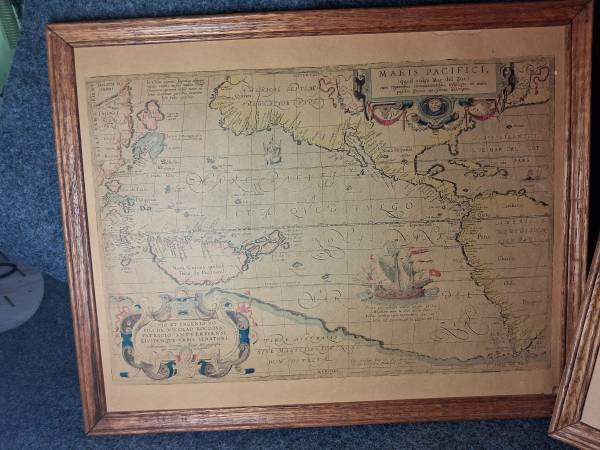
Very fun set of ancient style maps. Personal favorite zooming in for photos. Very cool.
Each print 15" x 12"
Right Print:
This is a reproduction of an original print of the highly celebrated 1626 map of Europe by John Speed, titled "Europ, and the Chiefe Cities contayned therein described; with the habits of most Kingdoms now in use."
It is one of the most famous examples of an early 17th-century English carte-à-figures (a map bordered by costumed figures and city views).
Key Features of the Map
• Top Border (City Views): Features panoramic, bird's-eye views of eight principal European cities of the era: London, Paris, Rome, Constantinople, Venice, Prague, Amsterdam, and Lisbon.
• Side Borders (Costumes): Depicts couples dressed in the traditional, contemporary costumes of different European nations, illustrating the "habits" (clothing styles) of people from England, France, Germany, Spain, Italy, and more.
• The Map Content: Reflects the geographic knowledge of the early 1600s, including speculative details, decorative sea monsters, and sailing ships in the Atlantic and Mediterranean oceans.
Center print:
This framed piece features the Nova Totius Terrarum Orbis Geographica ac Hydrographica Tabula, a legendary seventeenth-century double-hemisphere world map originally designed by Dutch cartographer Henricus Hondius in 1630.
Historical Significance
• Early Australia: It is famously notable as the first dated map published in a widely distributed atlas to show any portion of Australia (specifically the western coast of the Cape York Peninsula mapped in 1623).
• Cartographic Myths: The map showcases standard seventeenth-century geographical misconceptions, including depicting California as a large island off the coast of North America.
• Artistic Borders: The original composition features intricate, allegorical corner illustrations representing the four elements (Earth, Air, Fire, Water)
Left Print:
A framed reproduction of Abraham Ortelius' famous 1589 cartographic masterpiece, "Maris Pacifici" (The Pacific Ocean). It is widely celebrated by historians and collectors as the first dedicated printed map of the Pacific Ocean.
Core Details & Features
• Cartographer: Created by the legendary Flemish cartographer Abraham Ortelius, who is also famous for compiling the first modern atlas (Theatrum Orbis Terrarum).
• Full Title: Maris Pacifici (quod vulgò Mar del Zur) cum regionibus circumiacentibus, insulisque in eodem passim sparsis, novissima descriptio. This translates to: "A new description of the Pacific Ocean (commonly called the South Sea), with the surrounding regions and its islands scattered here and there."
• Historical Highlights: The map prominently features Ferdinand Magellan's flagship, the Victoria, sailing through the Pacific. It reflects 16th-century geographic understandings (and misunderstandings), including a massive undivided North American landmass and a fictionalized Great Southern Continent (Terra Australis) at the bottom.
Great for a gift or for self. All appear to be dot-matrix color print. Vintage condition. Wonderful addition Great conversation piece. 🥂